Department of Hydrmeteorology in the frames of its competence provides all interested physical persons and legal entities with the following chargeable data and services:
Forecasted data
Short-term weather forecasts (for the territory of Georgia in accordance with physical-geographical regions and points);
Middle-term weather forecasts (for the territory of Georgia in accordance with physical-geographical regions and points);
Monthly weather forecasts for the territory of Georgia (for physical-geographic regions);
Forecast of daily water discharge on river Kura, near Tbilisi (in case of interest for other rivers too);
Three day water content forecasts on major rivers in Georgia;
Decade/monthly/quarterly water discharge forecasts on major rivers of Georgia;
Forecasts on spring flooding parameters and water content during April-December period for major rivers and water reservoirs of Georgia;
Over-short term special forecasts and warnings on snow avalanche threats;
Regime (Historical) Data
Meteorological information of the current day, received from observational network (air temperature, atmospheric pressure, wind direction and speed, atmospheric processes);
Daily information from the hydrological posts (water level and relevant discharge);
Information regarding conditions of Sioni water reservoir;
Metadata on meteorological stations and posts;
List of the elements observed on meteorological stations and posts:
a. Air temperature 0C (average, maximal, minimal);
b. Temperature of the soil surface 0C (average, maximal, minimal);
c. Air humidity (partial pressure of water steam, saturation deficit, dew point, relative humidity);
d. Hourly information on air temperature and relative humidity received from self-recorder;
e. Atmospheric pressure in hectopascals (on the station level, sea level and barial tendency);
f. Precipitation amount (in mm);
g. Wind (speed in m/sec, direction);
h. Weather on term and between the terms;
i. Cloudiness (shape, number, height);
j. Visibility (in km);
k. Conditions of soil surface (description);
l. Snow cover (height, quality of snow coverage, description of snow cover spreading, description of snow conditions, snow density);
m. Duration of solar lightning (hourly);
n. Temperature of soil depth (5, 10, 15, 20 cm);
o. Hazardous hydro meteorological phenomena.
Physical-geographical description and history of meteorological stations and posts;
Preparation of meteorological tables (daily 8 term meteorological observations and generalized results for meteorological elements) for each meteorological stations and posts with month periods;
Natural conditions/hydro morphometry of rivers and their basins;
Description of hydrological posts;
Daily observation data on water objects (river, water reservoir):
Water level;
Water discharge, stream speed, runoff;
Water temperature;
Water turbidity;
Suspended load discharge;
Granulometric composition of loaded materials;
Water level in water reservoirs;
Water temperature of the water reservoir at the bank, surface layer of the water area and other different depth;
Heating resources of the reservoir’s water mass;
Water balance of the riverbed;
Water balance of river basin and water reservoir;
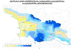
Daily, seasonal, annual and multiyear data on water cadastre at hydrological posts (land surface waters, regime and resources);
Multiyear and other provisional discharges for river mouths;
Monthly, annual, minimal, 30-days, extreme and different provisional discharges at river posts;
Glacial processes on rivers and water reservoirs;
Daily, monthly, annual and multiyear data on water evaporation from surface;
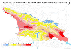
Territory zoning in accordance with frequency and intensity of hazardous hydro meteorological processes (snow avalanches, drought, abundant precipitations, strong winds, mudflows and others)
Climatic Data
All types of certain climatic characteristics (air soil temperature, air humidity, atmospheric precipitations, snow cover, wind, cloudiness, fog, thunder storms, hail, snow-storm, solar radiation and radiation balance, solar lightning) for meteorological posts and stations;
Complex climatic characteristics:
a. Construction-climatic norms:
Temperature under review;
Reiteration of the coldest five days;
Average temperature of the heating period and duration of the period;
Average number of degree-days;
Wind speed under review;
Unique complex of wind and rain;
b. Climatic index of tourism;
Territory zoning maps of Georgia, created on the basis of GIS technologies in accordance with climatic characteristics;
Long-term climatic forecast (2020-2100) for the territory of Georgia, in accordance with different scenarios, based on global long-term climate forecast for south Caucasus.
Agro meteorological Data
Decade/annual agro meteorological bulletin (enclosed with tables and schematic maps);
Agro meteorological review of the year (enclosed with tables, graphics and diagrams);
Special agro meteorological review on agricultural crops and cultivation works during diverse conditions and about influence of expected weather;
Phenological data and forecasts on agricultural crops;
Services
Calculation of multi year, maximal, minimal and different provisional discharges for different crosses on unstudied rivers;
Water discharge and speed measurement;
Runoff calculation;
Identification of critical flooding level;
Identification of inundation zones;
Identification of mudflow zones;
Monitoring over solid and bottom load materials;
Identification of river depth;
Measurement of creeping sediment discharge;
Identification of granulometric composition of solid sediment materials and their density;
Hydrometric works on lakes and water reservoirs;
Channel calibration;
Monitoring over glaciers of Georgia;
Identification of snow cover height, density and water content;
Establishment of hydrological posts on lakes, water reservoirs, rivers and channels and monitoring;
Identification of thermal regime on the lakes and water reservoirs;
Measurement activities;
Identification and study of snow avalanche hearths;
Identification of snow avalanche speed and hitting power;
Arrangement and implementation of activities connected with artificial descending of snow avalanches, hail preventive measurements, precipitation and thunder storm regulating, fog clearing and spring freeze preventive activities;
|